Monday, August 30, 2010

Sudak

When we bypassed Alchak mountain, we saw coast of Sudak and mountains behind it. They were our last points of route. Thus, after passing Sudak coast, we reached fortress mountain, where ancient fortress is located. It was founded in Middle Ages and belonged to different people in different times. But the most buildings of it were built by Italian colonists in XIV century. We walked in Sudak fortress more then an hour. But, if we had more time, we could spent more time there.
After that we left the city and went west by automobile road. We moved to one of the highest mountain in this region - Sokil. It isn't the highest one, but it has the most rapid slopes, which rises above the sea coast.
We spent the night on the mountain pass to the north of Sokil and ascended its summit next morning. Then we passed some mountains and returned to Sudak, where we sat down for transport home.
I made a lot of photos about Sudak, its fortress and towers, and, also, about our climbing Sokil summit. Here some of them:

View of Sudak coast


Mountain with Sudak fortress


Fortifications of Sudak fortress


Ruins of ancient walls


View from mountain Sokil

Wednesday, August 25, 2010

Sonyachna Dolyna

After Kinomistechko we left sea coast and went directly to the west. Coastline makes bend here, which is called Meganom. Meganom also is a mountain, so we decided to avoid the climb and go through Sonyachna Dolyna (Sunny Valley), which located north of it.
The valley proved to be really sunny: trees were rare and small. Landscapes were very opened. While going we found only a couple of water reservoirs and no river. But people have used such a climate for growing grapes: all fields and gentle hills around were covered with vineyards. And, if you know, Sonyachna Dolyna is one of the famous Ukrainian wine brands.
After crossing Sonyachna Dolyna we made a camp on the mountain near source Ai-Georgiy. This place is elevated over the valley, so we could see the wide scenery with Meganom in the end.
The next morning we left this sunny valley. We returned to the sea and went around mountain Alchak. Passing the mountain we have entered another great valley, where city Sudak is situated. But it is a material for the next part of this story.
And here you can see some photos:

Lake near Sonyachna Dolyna


Ancient church in Sonyachna Dolyna


Vineyards

Our camp on the west of Sonyachna Dolyna. In background - mount Meganom

View of Sudak bay from Eol's grotto

to be continued

Thursday, August 5, 2010

From Karadag to Kinomistechko

From Kara-Dag we went west. First part of our route lied on the coast of Bleak Sea. If you look at the map, you will see, that this is territory without any forest. Only stones and clay are around. Some hills even have no grass on theirs slopes.
But there are some interesting places. First time of our walking along the coast we could see dark shape of Kara-Dag mountains. And some hours later we entered ruins of Kinomistechko. It is tiny town of mould houses, which ware built about five years ago specially for shooting adventure film about middle-ages East.
So here are photos of our walk along the sea, including ones with view of Kara-Dag. And, of course, interesting pictures from Kinomistechko. Some of them:


Dark mountains of Kara-Dag


Sea ground with lines of seaweeds


Grass-less slopes on the coast of Bleak Sea


Inside Kinomistechko


View of ruins of Kinomistechko

To be continued

Friday, July 30, 2010

Karadag

One of the main purposes of our travel was to visit the Nature Reserve Karadag. So, the most of the third day we spent on its territory.
In the morning we left our camp near Echki-Dag and went to the town Schebetovka, which is located at the western edge of Karadag and lies on the road from Feodosiya to Sudak. So, if you go to Karadag by car, you will cross this town.
We entered Karadag through the coast village Kurortne, to the south from Schebetovka.
Here some photos from our visiting Karadag.

The Golden Gate

High rocks over the sea

Stone face looks into the valley of Karadag

Ruins of the ancient volcano


Magnetic range

More photos from this day of our travel you can find in online-photoalbums. They show our way to Karadag, rocks of Karadag, Karadag with the sea and other places in Karadag.

Monday, July 19, 2010

Kyzyltash

After visiting Surb-Khach, we have a night in the next forested valley after monastery. By the way, there we found ruins of another ancient monastery - Surb-Stepanos. But it was in worse condition than Surb-Khach. The next morning we went south. After some hours in mountain forest we suddenly got into garden of another live monastery - Kyzyltash. If you want to go by car from Surb-Khach to Kyzyltash, you should make a greate "circle". But, going by foot we could went from one to another in rather shorter way.
Like many others, Kyzyltash monastery didn't act in Soviet times. But, what is most interesting, Soviet government had made military object in this walley, where nuclear weapon was storaged. Now here are no nuclear weapon, but army unit still acts and occupies a large part of valley just near the monastery.
We looked interesting places in Kyzyltash, especially sacred spring and new wooden church. Then we walked accros willage and saw army unit. After that we went into forested mountains again. To the evening we reached eastern corner of Echki-Dag. There we made a camp with a beautiful view of Kara-Dag and Black Sea in the south.
Links in the text lead to online-photoalbums. Some photos from there you can see below.


Ruins of Surb-Stepanos

New church in Kyzyltash


View of Kyzyltash monastery


Former nuclear object


Morining in Echki-Dag

to be continued

Tuesday, July 13, 2010

Staryi Krym

Last spring we traveled to the southeastern part of Crimean peninsula. This is a region of old Crimean capital (Staryi Krym), several ancient monasteries (Surb-Khach, Surb-Stepanos, Kyzyl-Tash), one of the most enigmatic Natural Preserve (Kara-Dag) and medieval Genoas fortress of Sudak. That all we visited for a week.
Our travel started in Staryi Krym. It is one of the oldest cities of Crimea. It was founded in the X-th century and till XV-th century it played the main role of Crimean government. Then it was called Solhat. Once Bakhchysaray became the capital of the peninsula, Stary Krym lost its strategic importance. Since that time it received nowadays name which means "Old Crimea".
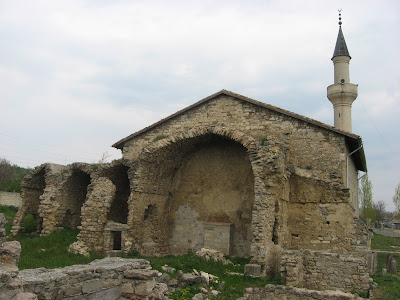
We begun our travel with a visit to the ancient mosque - Uzbek's. It was built in 1314 and now part of building is ruined. But even in this condition it looks very interesting.
Another interesting historical sites in Staryi Krym is an ancient Armenian monastery Surb-Khach. It was founded in 1358 and still acts. Only in 1778-1790 and 1925-2002 years its religious life were interrupted. So, we were able to see ancient buildings, rows of khachkars (Armenian icons) and different interesting things inside.
You can see photos from that places in my photoalbums: Staryi Krym, our first steps, Surb-Khach and its interiors. Here are some of them.

Ruins of Uzbek's mosque in Staryi Krym

First climbing. In the background - Staryi Krym


Church of Surb-Khach's monastery


Entrance of Surb-Khach


Khachkars - Armenian analog of icon

Thursday, July 1, 2010

On Tarasova Gora

After visiting Kaniv we went to its' southern edge, where Kaniv Natural Preserve is located. It lies on the wooded hills on the right bank of river Dnipro. The highest hill is called Tarasova Gora (Taras' Hill), because the famous Ukrainian poet and artist Taras Shevchenko was buried there. Now on the top of this hill his memorial complex (Museum, Monument and Park with few memorials) is located.
We came from the river side. From foot of hill to upper territory leads interesting stairs. We coped with them and then got fantastic view on the top of hill.
While walking there I made many photos about Tarasova Gora, alley of characters from Shevchenko poems and just about golden autumn. Here are some of them.

Stairs to the top of Tarasova Gora


Museum and Monument of Taras Shevchenko


Interior of traditional Ukrainian house


Alley of characters from the poems by Shevchenko


A view from Tarasova Gora in autumn

Tuesday, June 29, 2010

In Kaniv

In the autumn we traveled to Kaniv - a city in the central Ukraine. It is located on the right bank of the river Dnipro. Here was built one of the largest Ukrainian hydroelectric power station. That is why storage reservoir, which stretches to the southern border of the capital of Ukraine, called the Kaniv Reservoir.
There is another interesting fact about the city. It has a long history - Kaniv mentioned in chronicles since 1144. The most ancient building, which has been preserved to our days is Uspenski Cathedral. It was built 866 years ago. And it was the temple where was held funerals for Taras Shevchenko, the man-symbol of Ukraine.
So, we had an interesting walk in Kaniv. Walking the town I made a lot of photos: about some interesting places, in particular monument of Ivan Pidkova, about Dnipro, and, of course, about beautiful autumn flowers. Here some of them:

Kaniv historical museum

Uspenski Cathedral, which was built 866 years ago


Right bank of river Dnipro


Monument to the legendary Cossack Ivan Pidkova

Bouquet of autumn flowers

But the most interesting materials about this travel will be published in the next post.

Tuesday, June 22, 2010

In Yalta

Our last camp was made near the final point of our travel - Yalta. The slope of the mountain has appeared to be too inclined so we set up our tents just on the forest road. No one went this road until the morning, so we had got quiet night.
In the morning we went to Yalta - one of the most popular cities in the southern coast of Crimean peninsula. Our tourist trip with backpacks and tens was over and we finally could enjoy a simple walk in the center of this beautiful city. We also went to the city quay and saw Black Sea. A few hours later we leaved Yalta by mountain trolleybus (the longest trolleybus line in Europe) and returned to Simferopol.
Here are some photos from the last day of our travel.

Our camp near Yalta


Vineyards

In the center of the city

Yalta Quay

The Black Sea

See more photos from the last day of our travel in photoalbums here and here.

Wednesday, June 9, 2010

Yaltynska yaila

The next stage of our travel was the most higher in the whole trip. For more then an hour we were going along Yaltyska yaila into clouds at a high of 1300-1500 meters. The road ran on the edge of yaila. And if the weather was good we would see a broad landscape on the south with the Black See on the horizon.
Thus, only when we went mountain Djady-Burun and started to come down from yaila, we left the clouds and we could at least see all the landscapes below. They were amazing. You just can see in these pictures:

A road on Yaltynska yaila


Our group


Rocks on the edge of yaila


View on Yalta from yaila


View on the Black Sea coast

More photos of this part of our travel see here and here

To be continued